
A cyclonic circulation lies over the southeast Bay of Bengal and the adjoining south Andaman Sea extending up to middle tropospheric levels. Under its influence, a low pressure area is very likely to form over the southeast Bay of Bengal and neighbourhood during the next 24 hours.

It was a repeat of scenes witnessed last month as motorists struggled to manoeuvre their vehicles on flooded roads and subways while showers led to traffic congestion in Chennai and suburbs.

The seasonal temperature would be above normal by more than one degree Celsius over Northwest India.

According to the officials of Tirumala Tirupati Devasthanams, one of their sanitary workers was badly injured due to the storm and calamitic conditions in the state.

Brace for some warmth this winter as the India Meteorological Department (IMD) in its December-February forecast on Thursday said that the minimum and maximum temperatures could remain 'normal' to 'above normal' over most parts of Northwest and Northeast India. Both the minimum and maximum will remain below normal in Southern Peninsular and Central India in these winter months. While this could give some respite from the intense cold of North India, it could have a negative impact on the standing rabi crops if the temperature rise is unusual and abnormal.

Ten to 20 days of heatwave are expected against the normal of four to eight days in the entire April-June period.

'We have not even used 0.1% of the available resources.'

The death toll due to severe heat wave sweeping Andhra Pradesh has risen to 852 with the scorching weather claiming 202 lives in Prakasam district alone, officials said.

Monsoon normally hits Kerala on June 1 but this year, Met department had predicted that it will hit the state on June 5.


The IMD has issued a red-colour coded warning for the southern areas of Tamil Nadu Kerala in view of the brewing storm and said that these areas are expected to receive heavy to very heavy rainfall.

Rain and thundershower lashed many places in Ganjam, Khurda, Puri, Cuttack, Jagatsinghpur, and Balasore in Odisha, disrupting normal life, the weatherman said.

'There's also a possibility of the cyclonic system changing its course, thus avoiding a landfall in Odisha'

Discover our country through great Indian rail trips!

Mercury hovered around 40 degrees Celsius in large parts of the country on Monday as the Indian meteorological department predicted heat wave conditions in parts of east India over the next four days and the northwest region over the next two days.

Thunderstorms and dust storms are 'very likely' on Tuesday too, the weather office warned.

IMD has said the temperature in April-June across most parts in India is expected to be 0.5-1 degrees Celsius warmer than normal. However, doctors and scientists say they haven't found any direct correlation between the speed of COVID-19 spread and warm weather.

The system lay centered at 5.30 am over Southeast Bay of Bengal, about 450 km west-northwest of Car Nicobar (Nicobar Islands), 380 km west of Port Blair (Andaman Islands), 970 km southeast of Visakhapatnam (Andhra Pradesh) and 1030 km south-southeast of Puri (Odisha).

Twelve of the 36 meteorological subdivisions recorded deficient rainfall, while the rest witnessed normal to excess rain. In total, 38 per cent of the 662 districts received below-normal rain.

Cyclonic storm Hudhud will turn take a 'very severe' turn in the next 12 hours, bringing with itself very heavy rainfall and gusty winds as it inches closer to the coast, the MeT department has said.

A well-marked low-pressure area over southwest Bay of Bengal intensified into a depression on Thursday morning packing wind speed of 40-50 kmph as it moved towards the north Tamil Nadu coast, the weather office said.

Severe cyclonic storm Mandous will cross the coast between north Tamil Nadu and south Andhra Pradesh around December 9 night and early next day, the regional weather office said on Friday.

According to the India Meteorological Department (IMD), the Ayanagar weather station recorded 99.2 mm rainfall, the maximum in the city, during the 24-hour period ending at 8.30 am on Thursday.
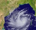
Cyclone Hudhud has moved closer to the cost of Odisha and Andhra Pradesh and will turn into a severe cyclonic storm in next 12 hours, the India Meteorological Department said.

The weather office on Monday forecast heavy to very heavy rainfall over the next three days over some parts of Uttarakhand, which is still recovering from a deluge last week that is feared to have taken over 1,000 lives.

Here are some important Do's and Don'ts to follow during a heatwave so as to avoid sunstrokes

A peek into the life of a public-sector banker who did well professionally, but paid a price for it, points out Tamal Bandyopadhyay.

Educational institutions remained closed even as the weather office forecast heavy downpour in the next three days in the state, Puducherry and coastal Andhra Pradesh.

The orange alert has been issued for moderate or heavy thunderstorms and wind speed with 30-40 km per hour to reach some districts of Odisha within the next three hours.

Only traces of rainfall were recorded in a few areas of the national capital on Thursday which continued to experience sultry weather.

Heavy rains continued to pound Chennai and nearby districts on Monday under the impact of a cyclonic storm, which is likely to cross the coast in Andhra Pradesh on December 5.

The southwest monsoon might finally start withdrawing from parts of North-West India over the next three days, signaling the end of its four-month journey over the country that started in June, the India Meteorological Department (IMD) said. However, though the retreat might begin from next week, the rains might not descend quickly, as the met department predicted fresh spells of rains in Vidarbha, Chhattisgarh and east MP on September 21-22 and over Odisha, Coastal areas north Andhra Pradesh and Gangetic West Bengal on September 19-21. "Due to anti-cyclonic flows over northwest India at lower tropospheric levels, dry weather is very likely over west Rajasthan, Punjab, Haryana, Chandigarh and Delhi during the next five days. "Hence conditions are becoming favourable for the withdrawal of Southwest Monsoon from parts of northwest India during next three days," the IMD said.

The India Meteorological Department said rainfall would be accompanied by gale wind speed reaching 140 to 150 kmph and gusting to 165 kmph along and off Odisha and north Andhra Pradesh coasts.

Heavy rainfall coupled with strong winds continued to lash several parts of Chhattisgarh on Monday due to cyclone Hudhud, which hit coastal Andhra Pradesh and Odisha on Sunday.

East India, along with a major portion of central India, is likely to be at a higher risk of being rain deficient, especially during the first half of the season.

Meanwhile, water will be released from Chembarambakkam lake, one of the key drinking water sources to Chennai, since it was nearing capacity, the government said.

The killer heat wave brought the nationwide toll to 2,338 even as some places like Delhi got respite on Monday.

Parts of south, east and northeast India are expected to get some relief from the blistering heat, with the onset of monsoon expected to take place over Kerala on Saturday.

In the first of a two-part series, Business Standard examines the impact of the upcoming summer on agriculture and drinking water supply.

As Cyclone Hudhud is closing in on the Andhra Pradesh coastline and is expected to make a landfall near Visakhapatnam by Sunday afternoon, about 1.11 lakh people in five coastal districts have been shifted to safer places.
